31 August 2014

To Lyon

On Thursday, 24 July we had secured to a masonry wall in Tournon after three days of travel and 209 kilometres against the current up the rivers Petit Rhône and Rhône from the Midi. We had paused for three days in Viviers to await the passing of a spate of fast current from heavy rains in the drainage basins of le Rhône and l’Isère. If we had opted to run against the heavier current instead of waiting in Viviers, we would likely have reached Tournon at the same time, taking three days, burning much more fuel and needing to refuel along the way. As it was, our fuel tanks were getting low, showing about 80 litres remaining. At 0710 on Friday we slipped and continued.

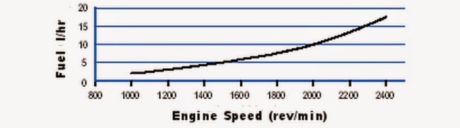
Our goal was to reach the fuel dock in the marina in les Roches-de-Cordrieu 50 kilometres upstream before running out of fuel. Zonder Zorg burns about 3 litres per hour at 1200 rpm, which in still water gives a speed of 8 km/h. She burns about 7.5 litres per hour at 1800 at a speed of 12 km/h. With the expected current running around 6 km/h, 1200 rpm would take us 25 hours and 75 litres to make the fuel pump. Upping the engine speed to 1800 rpm would give us a speed over the ground of about 6 km/h, which would require 8 hours and 20 minutes and burn 62.5 litres. At 2000 rpm our speed over the ground would increase to a little over 7, taking us a little under 7 hours of motoring and burning just shy of 70 litres. I calculated that the sweet spot for time and fuel with the prevailing current was around 1900 rpm, so that’s where I set it.

Écluse Gervans was ready for us shortly after we arrived and we made a quick passage up it. The bypass canal is short and we were soon out again into the broad river and making good speed. As we passed the ruins of Tour d’Aras, we met a down-bound klipper tjalk. We continued to use the slower current in the lee below the bends to increase our speed. At times we were making close to 11 km/h.

As we approached Andance we found a stronger current, which slowed us to just above 6 km/h. Upstream of Andance, we were foiled in our desire to find slower currents at the edges of the river and in the lees of the bends. A six kilometre stretch here has groins not far underwater extending well into the river to train the channel down its centre. We were forced to remain in the full force of the current. Shortly after the end of the section of groins, we entered the canal leading the next lock, Écluse Sablons and the fast current continued.

Fortunately, the diversion canal below the lock is short and the lock was being readied for us as we arrived. Out of the lock there is a nine kilometre canal, where the current allowed us to make 7.5 km/h. As we broke out of the canal into the wide river, our speed increased to near 10.

We continued to meet down-bound traffic, this one a deeply laden bulk carrier as we approached the vineyards of Condrieu. 

Condrieu and Château Grillet are planted with Viognier and winemakers around world have long used the wines produced here as their benchmark for that variety. Fortunately for consumers, Viognier wines of equal and better quality are now regularly produced in vineyards around the world at substantially lower prices, leaving these Rhône ones to the label drinkers.

At 1516 we arrived in the marina in les Roches-de-Cordrieu with no diesel left visible in the sight glass on our fuel tanks. We had motored a total of 7 hours 35 minutes and had spent 31 minutes with the engine off in the locks. I figured we had burnt about 67 litres and had about 13 remaining. 

We refueled at €1.45 per litre, about 12 cents above the road station price, but the cheapest waterside pump we had seen since a tanker truck delivery the beginning of April in Carcassonne.

It was still early when we had finished fueling, but there were still 41 kilometres and two locks remaining to Lyon. The final lock was 37 kilometres along and there was insufficient time remaining to make it through before it closed for the day at 2100. We took a mooring on a T-head in the marina and, while I walked to le boulangerie for a fresh baguette, Edi prepared a nibbling tray for a late lunch.

After a leisurely breakfast, we slipped at 0925 and continued up le Rhône. Above Condrieu, the river bends so that the slopes above the Right Bank face south-east. The vines change from Viognier to Syrah as we approached the town of Ampuis, where we were looking up at the vineyards of Côte Rotie, the Roasted Slope. Like with the Viognier in Condrieu, winemakers around the world looked on the wines of Cote Rotie and Hermitage as the holy grail of Syrah wines. Again, fortunately for the wine lover, Australia, California and British Columbia, among other New World wine regions are now making as fine or finer Syrah wines at lower prices, leaving these Old World examples for those who prefer to drink fame and reputation instead of quality and appropriate pricing.

Our luck with the locks continued as we arrived at Écluse Vaugris just as a large commercial began entering. We followed it in and rode up the 6.7 metres.

Out of the lock we quickly rejoined the broad river and were making good speed against the current, which seemed about 5 km/h. Upstream of Vienne we were quickly overtaken by a full lock length convoy of two barges and a pusher. Fortunately the next lock was sufficiently far ahead that it would be well through and clear before we were anywhere near.

As we approached the final lock, Écluse Bénite, we were overtaken by another commercial. 

This one was only 130 metres long, so there was still 60 metres left for us to settle in astern.

At 1540 we passed the bifurcation beacons marking the confluence of le Rhône and la Saône. We bent our course slightly to port and started up la Saône into Lyon.

The creative, colourful and highly unconventional architecture along the banks of the mouth of la Saône was as startling when we viewed it heading upstream as it was when we first saw it on our way down last year.

I had emailed Place Nautique de le Confluence and had received no response. I had been phoning as we came up river and as we neared, I called them on VHF on their listed CH18, all with no response. We arrived, entered the port and saw one open spot. We backed into it, dropped the spud pole and at 1600 secured the stern to a five metre finger. I went looking for le Capitaine, but the office was closed. Remembering the huge Carrefour supermarket in the shopping centre off our bow, we grabbed our shopping bags and headed across the passarelle. In the wine department we saw some representative bottles from the vineyards we had been passing. Remembering the days when I drank these for a tenth of the price, we decided to continue passing.

We stocked-up for our planned continuation up la Saône then went back to Zonder Zorg. In the evening we enjoyed a fine dinner of seared dos de cabaillaud with a sprinkle of cumin, crisply sautéed pleurottes, steamed green beans and sliced roma tomatoes with shredded fresh basil. Accompanying this and to celebrate our ascent of le Rhône, we had a bottle of Rebmann Crémant d’Alsace Brut Rosé.

27 August 2014

Continuing Up le Rhône

Shortly after 1600 on Monday, 21 July we had secured stern-to in the small marina in Viviers as we expected the current in le Rhône to begin increasing. Across the fields behind us, an old flood plain of the river, was the town of Viviers, perched on a hilltop with a line of sheer cliffs. 

Through the evening we were hit by a series of severe thunderstorms, but Zonder Zorg’s spud pole held her bow securely. We hunkered-down inside and studied at the graphs on the CNR website, trying to make sense of the convoluted information. After decreasing until 1300, the reported current at Viviers began steadily increasing through the afternoon and evening.

Thirty-five kilometres upstream at Valence, the current had begun increasing at least six hours earlier in the day, which made sense based on a five or six km/h current over that distance. I saw that we could expect a similar 30% to 35% increase in the current at Viviers by midnight as the result of upstream rains in Geneva and Lyon made their way down.

L’Isère drains the basin on the western end of the Alps, and there had been heavy rains in the areas around Grenoble. The river, which dumps into le Rhône a short distance above Valence, showed a near doubling in its flow volume over the corresponding period. With two days of heavy rains upstream of us, we settled-in for a two or three day wait for the current to reduce to a manageable rate.

After breakfast on Tuesday we walked toward the base of the cliffs to visit the weekly market. It was mainly filled with trinkets for the hotel barge passengers and other tourists. There were a few produce stalls with prices considerably above reality and at the fish truck we saw dos de cabaillaud at €37.50 per kilo. In the supermarkets these are generally between €15 and €20. We walked away empty-handed and continued up the narrow, winding streets into the town.

The town dates to before the Roman conquest. It became the capital of the Gaulish Helvii tribe and in the late Roman period it grew in importance as a bishopric and the capital of Pays Vivarais.

On the highest point is cathédrale Saint-Vincent, the seat of the Bishop of Viviers. Its tower dates from the eleventh century and the remainder of the building mainly from the twelfth century; it was consecrated in 1119. Because of the narrow streets, steep hill and abrupt cliffs, it is difficult to get a photo of the exterior.

Inside, the apse is hung with a selection of very large tapestries with religious themes. These are difficult to view because of the poor light and the glare coming from the windows above them.

Behind the altar is an elevated platform with stairs, which allows a better viewing angle.

I climbed up the stairs to get a better look, but the glare from the windows made them very difficult to fully appreciate.

Back outside there is a large courtyard, likely once the bishop’s private gardens. It is surrounded on three sides by sheer cliffs and from it are views down over the town to the south and west.

To the north the river can be seen near the end of the line of trees that follow the road across the plain to the port.

Mid-afternoon, I pasted together portions of three previous screen captures of the water flow at Viviers to see the trend over the previous thirty hours. This showed the rate to have increased from slightly above 1400 when we arrived to slightly above 2200, an increase of nearly 60% in the current.

The following morning, the graph showed that the volume had paused slightly in the evening and then steadily increased overnight. It was now above 2400, an increase of about 70% from the time of our arrival.

The heavy rains had ended upstream and the past couple of days had been dry, so we expected to see an end of the spate of water coming down the river. On Wednesday afternoon we went to the supermarket to replenish our fresh supplies in preparation for a Thursday morning departure. The midnight graph showed a substantial drop in the flow, confirming our predictions. 

The online graph on Thursday morning showed the flow rate had continued its downward trend, and was sitting just above 1800 cubic metres per second. The pause in the decrease around midnight and the small rise through the small hours was most likely from flow control measures by the CNR when hydroelectric power demand dropped overnight. With industrial power demands increasing, I expected to see the drawdown to continue. 

Sitting on a masonry wall and a series of pylons just off our port bow were two large hotel barges, each with 150 to 200 passengers. Each day since we had arrived, two or three had moored here, either for the night or for several hours for the passengers to visit the town.

At 0725 we slipped, headed out of the marina, ran down the river half a kilometre and turned up the two kilometre canal leading to Écluse Châteauneuf. Not long after we slipped, the two river cruisers followed and before long, one was overtaking us. The lock is 190 metres long and each of the cruise ships was well in excess of 100 metres, so I knew only one of them would head in. 

I called l’éclusier and told him in a slightly questioning tone that we would follow Arosa Stella into the lock. He confirmed. Arosa Stella is within a few centimetres of the 11.4 metre width of the lock, and she took a long time to pump herself into the chamber.

There was plenty of room for the two of us in the chamber for the 16.5 metre lift.

We were soon out of the lock and into the eleven kilometre canal leading back to the river above the weir. The current was rather light above the lock, but nonetheless, I took advantage of the lee below the curves to gain some speed. Doing this, we often made speeds over the ground that were close to our speed through the water. 

We had to be careful with this, since there was down-bound traffic that would be embarrassing to surprise. Fortunately, the banks are mostly sufficiently low to see over the curves and we were never surprised by any traffic.

We were still in the canal as we passed Montélimar and found the current to be around 5.5 km/h, slowing us from 12 to about 6.5. We were pleased with our progress and pressed on.

Once we broke out of the confines of the canal and were back into the broad and deep river, the current decreased considerably. Our speed increased by three kilometres per hour.

At 1000, as we approached le centrale nucleaire de Cruas, we were overtaken by Van Gogh, the other cruise ship that had left Viviers with us two and a half hours earlier.

In an obvious attempt to show how friendly and benign the nuclear power installation is, one of cooling towers has a mural painted on its upstream face. It appears to depict an innocently nude child playing with sand on a beach.

Two kilometres upstream of the power plant, we passed le Port de Cruas. As we looked in at the floats, we could see two of the T-heads were unoccupied, so there was space for us if we wished to stop. We were making such good progress that we saw no need to cut the day short.

Half an hour later we arrived at Écluse le Logis-Neuf to find Van Gogh just beginning to enter. She had had to wait for down-bound traffic, so we slid in behind her.

At 1245 we were crossing the mouth of la Drôme, but saw negligible current flowing from it and we didn’t expect any change in our speed over the ground. We were making either side of 7 km/h, showing the river current to be about 5.

At 1320 as we were passing la Voute, we met an empty down-bound barge and saw a large river cruiser alongside the wall in front of the historic old town.

Three kilometres further along is Écluse Beauchastel, and by 1430 we were through it and continuing up its feeder canal. Edi brought up a board of open-face sandwiches to share as we motored.

At 1600 we were arriving at le Port de Plaisance de Valence, a huge marina just on the south side of the city with berths for 420 boats. We were delighted with our continued progress and decided to continue upriver. Our speed over the ground was in excess of 8 km/h

Half an hour later, just before we entered Canal de Fuit, the arm leading to Écluse Bourg-les-Valence, we were overtaken by Swiss Corona, a large river cruise ship. It appeared as if our luck with the locks was over; we would be too long arriving at the lock for the ship to wait.

We came around the bend immediately below the lock and saw Swiss Corona waiting for the lock to finish discharging a group of down-bound pleasure boats. 

We followed her in through the tunnel beneath the guillotine door and settled in astern of her for the ride up the 11.7 metres.

Out the top of the lock we were in the continuation of the bypass canal that runs another eight kilometres to take traffic back to the river. Half way along this is the confluence with l’Isère, which brings into le Rhône the major drainage from the western end of the Alps. As we approached the mouth of l’Isère we were slowed to below 5 km/h. 

After we had passed upstream of the confluence, our speed over the ground increased to nearly 7 km/h. We were still in the constricted canal and we expected to see another increase in speed once we reentered the river.

Our predictions were confirmed as we left the canal and regained the river. As we passed le Roche de Glun, our speed blipped between 9.3 and 9.5 km/h on the GPS, indicating the current was down to about 2.5. There is a moorage listed here, but we had decided to press on to Tournon, another eight kilometres along the river.


At 1915 we secured to a ring and a bollard on a masonry wall just upstream of Pasarelle de Tournon. We had come 77.0 kilometres on the day and were more than two-thirds of the way up the river to Lyon. Across the river from us rose the hill of Hermitage with la Chapelle on its crest above some of the finest Syrah vineyards in France. Blocking the view of Tain-l’Hermitage were five hotel barges lining the banks. These did not diminish the view in the foreground as we enjoyed a celebratory bottle of bubbly for our progress thus far.