08 July 2013

Enjoying Haarlem

With Zonder Zorg secured on the wall in central Haarlem, we paused. During the four weeks since we had arrived in the Netherlands, we have been going rather steadily, moving into Zonder Zorg and making her our home. While we still have some fine tuning to do, we are now finally ready to slow down and enjoy.

We enjoyed a leisurely breakfast on Friday morning, watching the passing parade of boats in the canal. We are just upstream of Gravestenenbrug, a small pedestrian and bicycle bridge that opens with a double bascule. It is 3.45 metres above the water in the centre, but toward the sides of the 10.7 metre span, the clearance is not much more than 2 metres. All the local tour and rental boats pass easily under it, as do many of the pleasure cruisers and barges.

Sailboats, of course need the bridge lifted, as do the large commercial barges. We watched as an unladen 40-metre barge came around the corner and slid by.

The brugmeister from Melkbrug, the swing bridge just upstream of us, opened Gravestenenbrug and we watched as the barge from Dortmund glided through.

We were midway through our breakfast when a converted luxemotor passed us heading downstream toward the closed Gravestenenbrug. I immediately spotted its navigation sidelights fixed to the top of the wheelhouse somewhat like Mickey Mouse ears. They looked to high to make it under the sloped bridge decks. As the barge approached the bridge, the crew went forward to lower the burgee mast, but the skipper ignored the nav lights until the last moment. With a belching of diesel smoke, he managed to stop before any significant damage was done. A standard pleasure boat height for France is 3.40 metres to fit under the usual 3.50 bridges, so I assume that the skipper, reading the 3.45 metre clearance on the chart, considered he would clear. After an embarrassing pause, the bridge was lifted for him and he continued down canal.

We finished breakfast without any further excitement and in the late morning we went walking in the old city. The sun angle on Sint Bavokerk was not at its best, and we told ourselves that we will have to come back in the early morning to get a better lit shot from Grote Markt, the only clear view angle. The narrow streets and tall buildings in the heart of the old city block views from other directions.

We wandered the many walking streets, which are lined with a grand selection of shops of mid-to-upscale merchandise. Not being in a shopping mode, we concentrated on the small lanes that weave a maze between the larger, though still narrow streets. Up one of these lanes we sighted Nieuwe Kerk, the new church which dates only from 1649.

Other lanes curved and wound their ways into tighter and tighter spaces.

All the lanes we saw were well maintained and exuded their owners’ pride. 

Late morning on Saturday the 6th of July, we hopped on our bicycles and pedalled northward out of Haarlem. We followed wonderful bicycle lanes and paths to and through Santpoort, Driehuis and Ijmuiden and came to the Noordzee Kanaal. With many dozens of others, we boarded the ferry for the free ride across the waterway. A sign on the ferry gives the maximum passenger load of 300, and it looks to have room for fifteen or twenty automobiles on its car deck. The ferry appears to shuttle back-and-forth with its only scheduling criteria being that everyone waiting has boarded, or that the ferry is full.

On the other side, we followed the cycle route signs to Beverwijk and then to Wijk aan Zee and pedalled past the house in which Edi was born. We continued up onto the dunes, and overlooking the North Sea, we paused on a restaurant patio for croquette broodje en bier to refresh ourselves from the eighteen kilometre ride.

After a wander among the dunes, we retraced our route back to Haarlem, pausing along the way to buy some fresh sole filets from a canal-side shack, which we had been told was the best place to buy fish in Haarlem.

On Sunday morning we dawdled over breakfast and were again too late in Grote Markt to get the sun on the east side of Sint Bavokerk. We did; however, have fine lighting for the buildings to the north and east sides of the square.

We continue to be amazed by the wonderful old buildings here. Their ornate facades display the obvious wealth that existed here during the sixteenth and seventeenth centuries.

After we had roasted in the midday sun, we went into Grote Sint Bavokerk to cool off. This was once the Catholic Cathedral of Haarlem, but in 1579 it was taken-over by the Protestants. The interior is finely decorated and the entire floor is made up of grave markers. Most noteworthy in the interior is the immense pipe organ, which was once the largest in the world. Herman Melville, in Moby Dick compared the inside of the whale’s mouth to the pipes of the Haarlem organ.

Many famous musicians have played this organ, among them Händel, Mendelssohn and Mozart. On the rear wall, beneath the pipes, is a plaque indicating that the ten-year-old Mozart played it in 1766.

Also toward the altar, among the many hundreds of grave markers, is the tomb of Frans Hals, the most famous painter of Haarlem. It was easy to find, with an advertising banner from the Frans Hals Museum standing over it. The banner announced a special exhibition comparing the painting style of Hals with those of Rembrandt, Rubens and Titian. We had already planned to visit the museum in the early afternoon, and this spurred us on.

We followed Grote Houtstraat for three blocks past the fashionable shops, then turned along Gedempte Oude Gracht a couple of blocks across to Groot Heiligland, which we followed past lines of row houses. These were once the city’s old folks homes. In one of them Frans Hals lived late in his life, and a series of them have now become the Frans Hals Museum.

Frans Hals was broadly admired early in his painting career for his bold approach, with large single brush strokes and for his rare ability to capture facial expressions, particularly smiles. He was also acclaimed for his ability to paint directly, without the need for preliminary outlines and sketches. His paintings are alive and fresh, particularly when compared to those of most of his contemporaries and predecessors.

Rembrandt, later in his painting career, adopted some of this bold and more casual brush stroke style.

Among the many paintings by Frans Hals in the museum, I was intrigued by this one of the Regents of the St Elizabeth Hospital of Haarlem. Halls had been commissioned to paint an official portrait of them in 1641, and I wondered whether any of these men were still serving when, years later Frans Halls appeared before the Regents for admission to the home.

Though not by Frans Hals, one painting caught our attention. It is a scene of the canal bank in central Haarlem, painted by G Breck Heyde in 1670. Its central theme is the De Waag, the Weigh House. There, goods were offloaded from barges, craned in through the front door, weighed for taxation, then moved out the side door and onto wagons or barges. Our skûtsje, Zonder Zorg is currently moored in front of De Waag, almost exactly where the wooden predecessor to our skûtsje in the centre of the painting is moored.

The scene has certainly changed today, with more modern boats along the canal side and some new buildings, such as Teylers Museum with the huge verdigris copper sculpture above its imposing facade. De Waag is still there, though now as a popular tavern.

In the early nineteenth century, the upper floor of De Waag became a painters association studio and classroom. In these spaces in the first half of the twentieth century, Edi’s father trained as a portrait painter and was admitted to the Portrait Artist’s Guild. If his ghost were to look out the studio windows today to the Sparne below, it would see Zonder Zorg.

We returned onboard, heads overflowing, but contented.

06 July 2013

From Ens to Haarlem

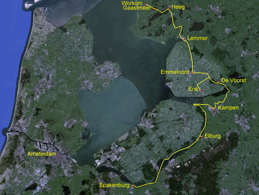
At 1000 on Saturday the 29th of June we slipped from the wharf in Ens and headed back out the blind Enservaart to the Lemstervaart and turned southward. Shortly after noon we arrived at Voorstersluis, which brought us back up out of the level of the Noordoostpolder. From De Voorst we followed the Kadoeler Meer southeastward to Zwarte Meer, which we crossed using the buoyed channels to the Scheepvaartgat, which led us in a strong cross wind to the Goot and along it to the Ganzen Diep.

Along the way we wound a very sinuous route through idyllic rural scenery.

Although Kampen is only 10 kilometres from Ens, the water route we had to follow linked together several canals and lakes and took us 36.3 kilometres. We arrived in Kampen at 1825 and secured to the melden pier in Jachthaven Seveningen to fill with water, and were told we could remain in place on the pier overnight.

The distance from Kampen to Elburg is thirteen kilometres overland; however, the shortest water route is 32.1 kilometres. The route follows the IJssel downstream to the Ketlemeer, where it goes around the end of a long dike and heads in the opposite direction up the beginning of the Randmeeren, the chain of lakes between the old Zuiderzee coast and the newly formed province of Flevoland. There were many huge commercial barges on the IJssel, but also a few smaller vessels.

As we headed around into Drontermeer there was a rather steady stream of pleasure craft coming and going, many of them under sail in the stiff breeze. The weather continued cold and bleak, with heavy mist alternating with rain showers throughout the day.

At 1305 we secured to the wharf in Elberg after a three-hour trip, the first part of which was aided by the current running in the IJssel. We cycled through the main gate of this medieval moated and walled city.

We admired the beautifully kept homes that abut the insides of the walls. The lanes are a profusion of flowers interspersed with patio furniture; the residents obviously enjoy their tiny front yards.

Lanes invited us to explore further into the old town.

A fifteenth century church stands solidly among stately houses of the same era and earlier. We spent two days relaxing and enjoying this wonderful place.

At 1035 on Tuesday the 2nd of July we slipped and headed out to continue our way around the Randmeeren. We followed the buoyed channel along Veluwemeer, passed through the open sluis at Hardewijk into Wolderwijd and followed its buoyed channel to Nuldernauw and then through Nijkerkersluis to Nijkerkernauw, which took us after a 42.6 kilometre day to Spakenburg. Not long after we secured to the wharf, a line of wooden botters paraded past.

There are about forty of these marvellously restored and maintained old fishing boats here in Spakenburg, many of of them dating from the late nineteenth century.

The botters were heading out for a regular evening sail on the Eemmeer.

After we had watched about thirty of them go past Zonder Zorg, we walked out to the end of the dike to get a better view of them sailing on the meer.

This is so dramatically different from an evening sail on Vancouver's English Bay that it seems we're on another planet. A few hours later, while we were having dinner aboard Zonder Zorg, the parade of botters came slowly past our salon windows.

In a light drizzle at 1400 on Wednesday we motored out of Spakenburg and continued around the Randmeeren. First we went northward along Eemmeeer and then northwestward along Gooimeer and finally north under the Hollandsebrug and into the southern end of Markermeer. It was raining rather persistently and the wind was gusting into Force 4 from the northwest, the direction we needed to go. We decided to seek shelter on the south side of a tiny uninhabited island, named Hooft.

At 1620 we tied to small trees on a dilapidated wharf in a space among half a dozen quasi-derelict boats and two considerably more proudly owned ones. We were secured out of the wind for the night. It continued to rain.

After a leisurely breakfast on Thursday morning, we slipped our lines and headed across Markermeer toward Buiten IJ and the entrance to Noordzee Kanaal. Marine traffic is nicely separated, with the central lanes for large commercial vessels and side lanes for smaller and recreational ones. The locks are also segregated, and we were the first to arrive and wait for the next cycling of the non-commercial side of Oranjesluizen.

We waited for about fifteen minutes as the lock tenders shepherded nine boats of various ages, shapes and sizes into the chamber. After all the juggling, we were lowered only about 20 centimetres.

We were then in the Noordzee Kanaal, which leads across Amsterdam and out into the North Sea. We motored with heavy traffic past central Amsterdam under clearing skies.

Westward, we were in the zone of the deep sea ships and passing the heads of many busy side harbours. Traffic became increasingly heavy and fast.

The wind built and we were butting into building chop. After about 30 kilometres we turned off the Noordzee Kanaal into Zijkanaal, which led us southwestward to Noorder Buiten Spaarne and onward into Haarlem.

At 1651 we secured to the wall of the canal in the heart of the old city of Haarlem, at the foot of the street up which 150 metres is the magnificent Sint Bavokerk, which has dominated the city skyline for at least six centuries. Beside us is Teylers Museum, the oldest museum in the Netherlands.

With Zonder Zorg in such a wonderful place, and with the weather finally looking a bit more summer-like, we have decided to pause here for a week and explore the area.

02 July 2013

To Schokland

On Thursday the 27th of June we had a light lunch of broodje gebakke schol from a trailer-booth in the weekly street market just in from the canal. Then at 1415 we slipped from our moorings on the wall in Lemmer’s basin to continue our voyage. 

As we backed and slowly turned, the Lemstersluis was being prepared to take us up to the level of the IJsselmeer. We didn’t have long to wait and there was only one other boat in the lock with us; a small sailboat. The lift was less than two metres and the entire process of waiting, entering, lifting and exiting took less than a quarter hour.

About a hundred metres onward from the lock we turned east and entered the Friesesluis that would take us down about seven metres to the level of the Noordoostpolder. Through the lock is the province of Flevoland, and we watched behind us as the doors closed on Friesland. We have very fond memories of our time in the land of the skûtsje, and we are taking Zonder Zorg away from her homeland again.

We motored out of the lock and followed the Lemstervaart through fields of crops on rich farmland that was three-quarters of a century ago reclaimed from the seabed. 

At Emmeloord we turned eastward onto the Zwolsevaart and motored past potatoes and grains. Along the way was a great assortment of waterfowl; ducks of various sorts, coots and swans among them.

A little over twenty kilometres along from Lemmer we came to the Marknessersluis in the centre of the town of Marknesse. As we approached, the lock was prepared for us, and we entered without pause. We were lifted about three metres to a higher level of the polder, and continued through rich farmland a couple of kilometres and then turned southwestward into the narrow Enservaart. We stopped for the night in a peaceful setting, secured to a solid wilderness wharf.

After a leisurely breakfast on Friday morning we continued along the Enservaart. It is a narrow, shallow canal, which by the spread of lily pads across the channel, is apparently little-used. We followed it to its end at the edge of the village of Ens.

There we turned in the small basin and secured to the well-maintained wharf. We had come to the end of this cul-de-sac because it is the closest approach to Schokland, which is only four kilometres away by bicycle.

Schokland is a former island in the Zuiderzee, which has a very long and complex history. The landform of the island, a low hilly ridge as one of the banks of the ancient River Vecht, originated as a glacial esker at the end of the last ice age. It was home to wooly rhinoceros, aurochs, mammoths, Irish elk and European bison; in the museum are displays of remains of many of these.

As the ice receded the ridge became the occasional home to roaming hunters and fishermen, with evidence of encampments ten thousand years ago. More permanent settlement of the area dates from about 6500 years ago. Archeological finds show that the Roman armies camped here. Significant is the bronze spearhead, the only one ever found in the Netherlands.

With the gradual inundation of the low lands and the formation of the Zuiderzee, the area around Schokland became marsh, and eventually sea by the end of the fourteenth century. The ridge had become an island. The inhabitants had been harvesting peat from the land, which had caused its further subsidence. 

The island was low and farm land was disappearing. Diking and draining were attempted, but the sea continued to erode the island. 

The written history of the Schokkers begins about five hundred years ago. For most of its history, the island continued to diminish and hillocks and dikes were washed away during storms. The few hundred inhabitants retreated to small hillocks on the eastern side of the island. Soon there was little more than three tiny settlements, Emmeloord, Molenbuurt, and Middelbuurt and some protective dikes. 

The population had become severely inbred and impoverished; seventy-five percent of the islanders were on welfare. By Royal decree in 1859, King William III ordered the island evacuated and the residents distributed among many communities along the Zuiderzee coast.

With the diking and draining of the area and the creation of the Noordoostpolder in 1942, Schokland was reclaimed from the sea. In 1995 Schokland became the first UNESCO World Heritage Site in the Netherlands. 

Today the former waterfront of Middelbuurt appears as an island in a sea of potato fields. The splendid small museum there tells the story much better than I can here. With our minds filled with images, we retreated to the security and comfort of Zonder Zorg in Ens to relax and to ponder what we had seen.